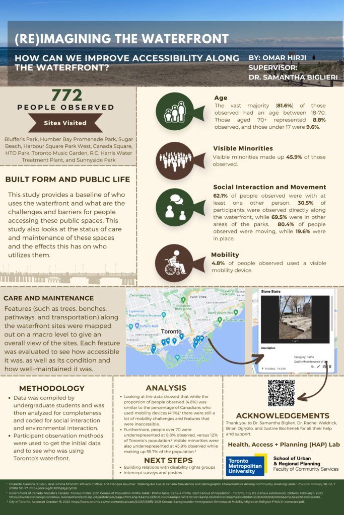
For our project (Re)Imagining the Waterfront, we wanted to see how we can improve accessibility along the waterfront. We wanted to get a baseline of data to see who uses the waterfront, for what purposes, and the challenges and obstacles that exist for people who wish to use these spaces. Furthermore, we want to examine the care and maintenance of these sites and the effects this has on people accessing these spaces.
Under the supervision of Dr. Samantha Biglieri, 100 third year undergraduate urban planning students at TMU were trained by Open Architecture Collaborative Canada (community partner) to use participation observation techniques to observe who they saw use a variety of public spaces on the waterfront. Students documented everything from water fountains to sidewalks, picnic tables and seating areas in 16 public spaces from the Scarborough Bluffs to the Humber River. Students also documented (using participant observation) who was using the park spaces and how. We documented over 700 people’s actions.
Students took photos of the built/natural environment features, plotted them using Google Maps and provided a written update as to the state of each feature, based on condition and accessibility – which are also represented spatially in Google Earth. This summer, our research team (including team member Brian Ogryzlo) then analyzed the data for accuracy and completeness. In total, 772 people were observed using 16 different waterfront sites on a weekday and weekend in March. We found that 81.6% of people observed were between the ages of 18-70, 45.9% of people observed were racialized individuals, and 4.8% of people observed were using a mobility device.
Looking deeper into the data, we found that although the percentage of people using mobility devices was similar to the Canadian average of 4.1%, we still documented several areas and features that were inaccessible. Furthermore, people over 70 were underrepresented at 8.8% observed, versus 12% of Toronto’s population. Racialized individuals were also underrepresented at 45.9% of people observed, compared to 55.7% of Toronto’s population. Moving forward, we want to use this data to track how people use the waterfront, and the care and maintenance of built environment features over time to help the planning and operation of these vital spaces in Toronto.
Bio: Omar Hirji is a student in his last year of the Bachelor of Urban and Regional Planning program at Toronto Metropolitan University. He has been working as a Research Assistant on the TMU team in April 2023, as part of the Undergraduate Research Opportunity at TMU. Omar presented this work in a poster at the URO showcase in September 2023, and it can be found attached to this piece.
Omar Hirji’s URO infographic poster is available below for Download and consultation:
To learn more about the research site led by Toronto Metropolitan University, click here.


